Annexation · Planning application
Meridian approves 65-home Lennon Pointe project with homes, townhouses and commercial lot
The approval annexes about 10 acres and allows 42 single-family lots, an 18-unit multifamily project and a commercial lot, with private streets through part of the site. The decision came at an April 26, 2022, hearing.
About this application
Annexation and Zoning of 10.41 acres of land with a request for C-C (2.1 acres) and R-15 (8.3 acres) zoning districts; Preliminary Plat consisting of 42 single-family building lots, 1 multi-family residential lot, 1 commercial lot, and 2 common lots on 8.8 acres of land; Conditional Use Permit for an 18 unit multi-family project; and a request for Private Streets through a portion of the site (administrative approval).
Project name on file: Lennon Pointe Community
Timeline
Dec. 28, 2022
Application Complete: Done
Dec. 28, 2022
GIS Final Review: Entered In GIS
April 26, 2022
Public hearing: Meridian City Council
Outcome: Approved.
April 26, 2022
Decision: Approved
Meridian City Council: Approved.
March 11, 2022
Final Action: Application Complete
Findings Signed
March 8, 2022
Public hearing: Meridian City Council
Outcome: Approved.
March 8, 2022
Decision: Approved
Meridian City Council: Approved.
Feb. 23, 2022
City Council Hearing: Approved
Feb. 22, 2022
Public hearing: Meridian City Council
Jan. 21, 2022
Planning and Zoning Hearing: Recommend Approval
Jan. 20, 2022
Public hearing: Meridian Planning and Zoning Commission
Outcome: Recommended Approval.
Jan. 20, 2022
Recommended Approval
Meridian Planning and Zoning Commission: Recommended Approval.
Jan. 13, 2022
Planning and Zoning Hearing: Continued
Dec. 2, 2021
Public hearing: Meridian Planning and Zoning Commission
Nov. 23, 2021
Planning Review: Approved
Nov. 18, 2021
Public hearing: Meridian Planning and Zoning Commission
Nov. 17, 2021
ACHD Review: Approved
ACHD sent their Staff Report on 11/17 for project.
Nov. 12, 2021
Floodplain Review: FLDP Required
A portion of this project lies within the Meridian Floodplain and Floodway Overlay District. Prior to any development occurring in the Overlay District a floodplain permit application, including hydraulic and hydrologic analysis is required to be completed and submitted to the City and approved by the Floodplain Administrator per MCC 10-6.All structures in the overlay district must be elevated to flood protection elevations.
Nov. 9, 2021
Parks Review: Approved
Pathways conditions uploaded to record
Nov. 8, 2021
Land Development Review: Approved
Oct. 26, 2021
Water Modeling Review: Approved
Engineering-Water Staff Report CommentsDistance from Existing System: 0Pressure Zone: 2Estimated Project Water ERU’s: See applicationWater Quality Concerns: NoneConsistent with Water Master Plan: YesComments for Staff Report: • **See the attached Water Markup for more details**• Pre-Plat sheet C-2.0 does not show the water main connection out to Ustick. This connection needs to be made and shown on the plans.• As currently designed, the utility layout does not follow the utility corridor. The water main must be located north and east of the centerline of the road. • The water main needs to connect south at the existing blowoff in N Zion Park Ave and connect east at the existing blowoff in W Pebblestone Dr.• Eliminate the proposed water main on the west side of Bldg B. The water main in the private road to the east of Bldg B can serve these townhomes.• Extend the proposed water main to close the loop within the private road. • Minimize the water main length at the commercial lot at the Northwest corner. Bring the water main into where a hydrant is needed and then take services from there to the two retail buildings.• Make sure that the water mains do not cross through landscaping or sidewalks.
Oct. 25, 2021
Wastewater Modeling Review: Approved
See Engineering - WW Staff Report Comments
Oct. 25, 2021
GIS Review: Approved
Oct. 21, 2021
MFD Plan Review: Approved
Comments uploaded to Accela and emailed to the clerk.
Oct. 18, 2021
MPD Review: Approved
Comments and level of service report submitted to planner and city clerk
Oct. 15, 2021
Transportation Plan Review: Approved
Streetlight plan required with the final plat.
Oct. 12, 2021
Reclaimed Water Review: Connection NOT required
Oct. 12, 2021
Floodplain Review: Manual Review Required
Oct. 12, 2021
City Clerk Review: No Comment
Oct. 12, 2021
Planning Cursory Review: Approved
Oct. 4, 2021
Legal Description Review: Approved
Sept. 28, 2021
Legal Description Review: More Information Required
Reached out to applicant on 9/28/2021. The City requires a legal description & exhibit map for the area to be annexed.
Sept. 22, 2021
Property Owners List Review: Approved
confirmed parcel from vicinity map submitted by applicant. Planner to confirm vcinity map parcel and further instruct if corrections are needed.
Sept. 22, 2021
GIS Cursory Review: Approved
Sept. 22, 2021
Application Submittal: Accepted
Sept. 21, 2021
Application Submittal: More Information Required
Missing AZ Exhibit, Vicinity Map and Subdivision name approval
Sept. 21, 2021
Application filed
Documents
Site plans
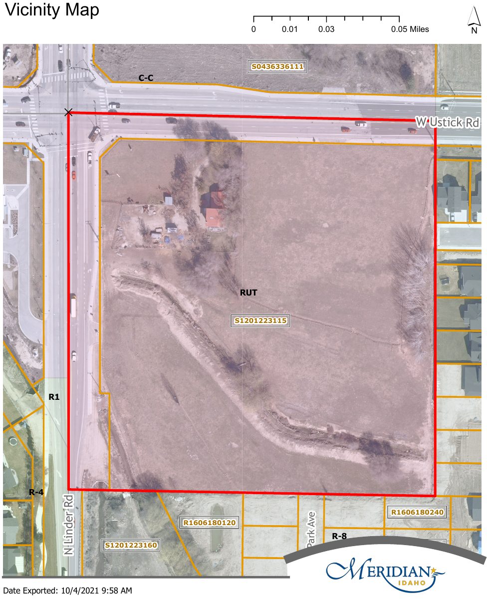
- Download Vicinity map (GIS export)
Vicinity map showing surrounding parcels, zoning labels and parcel identifiers, exported from GIS on 10/4/2021.
Oct. 4, 2021 · 1 page · 2.2 MB · Viewable by All
- Download Annexation legal description and survey map
Metes-and-bounds legal description of a 10.41-acre parcel in the City of Meridian, with a survey map labeled Exhibit B showing the annexation boundary.
Oct. 4, 2021 · 2 pages · 938 KB · Site Plans or Other Information
- Download Legal description and survey map for C-C rezone
Metes-and-bounds legal description and exhibit survey map for a 2.10-acre parcel proposed for rezoning to Community Commercial (C-C).
Oct. 4, 2021 · 2 pages · 882 KB · Site Plans or Other Information
- Download R-15 rezone legal description and survey map
Legal description and visual survey map for a roughly 8.30-acre parcel proposed for R-15 rezoning, prepared by a licensed surveyor.
Oct. 4, 2021 · 2 pages · 1.0 MB · Site Plans or Other Information
- Download Entitlement submittal package
Sept. 21, 2021 · 76.7 MB · Site Plans or Other Information
Plans
- Download Water utility markup, Lennon Pointe
Engineering markup sheet showing existing and proposed water and sewer utilities with general utility notes, including water main extension notes.
Oct. 26, 2021 · 1 page · 552 KB · Viewable by All
Staff reports
- Download Engineering staff report comments
Oct. 25, 2021 · 14 KB · Viewable by All
Application
- Download Planning application
Sept. 23, 2021 · 10.4 MB · Viewable by All
Correspondence
- Download Pathways comments
Nov. 9, 2021 · 52 KB · Viewable by All