Record of survey · Planning application
Four lots combined into two parcels in approved Highland Heights lot consolidation
The city approved, with conditions, a request to merge four lots in the Highland Heights Subdivision into two parcels. The decision is administrative and takes effect after a 10-day appeal period. The revised survey must be signed and certified, and utility and agency requirements met.
From the filing
The application's description as it appears in City of Boise's record. See the official record
The city approved a request to combine four existing lots in the Highland Heights Subdivision at 655 W Parkside View Lane into two parcels. The new parcels will be addressed as 663 W Parkside View Lane and 619 W Parkside View Lane. The approval is administrative and takes effect after a 10-day appeal period.
Parcel Consolidation
Project name on file: 655 W PARKSIDE VIEW LN
Timeline
Oct. 12, 2026
Review Complete: Completed
Oct. 12, 2026
Planning and Zoning: Complete
Oct. 9, 2026
Review Complete: Completed
Oct. 9, 2026
Planning and Zoning: Complete
Sept. 9, 2026
Planning and Zoning: In Review
Sept. 9, 2026
Assign Reviewers: Completed
Sept. 1, 2026
Fee Payment: Payment Received
Aug. 31, 2026
Prescreen Review: Passed
Aug. 28, 2026
Prescreen Review: In Progress
Aug. 28, 2026
Application Submittal: ePlanReview
Aug. 28, 2026
Application filed
Documents
Site plans
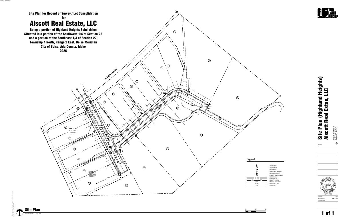
- Download Site plan for record of survey and lot consolidation
Survey site plan showing parcels E and F and surrounding utilities, including water, sewer, storm drain and pavement edges, drawn to a 1-inch-to-30-foot scale.
Sept. 23, 2026 · 1 page · 504 KB · PDS-Maps and Drawings
Project narrative
- Download Detailed letter of explanation for record of survey lot consolidation
Cover letter from a project coordinator requesting a lot consolidation that combines four lots into two parcels, with a parcel table and vicinity map.
Sept. 23, 2026 · 1 page · 376 KB · PDS-Letter of Intent
- Download Proof of legal parcel survey narrative
Survey narrative explaining the boundary basis, monument ties and referenced surveys for the Highland Heights Subdivision plat.
Sept. 23, 2026 · 6 pages · 3.6 MB · PDS-Other Small Docs
- Download Record of survey for lot consolidation
Record of survey consolidating four platted lots into two new parcels, Parcel A and Parcel B, with owner and city planning director certificates.
Sept. 23, 2026 · 1 page · 476 KB · PDS-Record of Survey
Decisions
- Download Action letter approving parcel consolidation with conditions
Boise City approves consolidating four lots into two parcels, subject to Record of Survey revisions and agency requirements, dated October 9, 2026.
Oct. 9, 2026 · 3 pages · 194 KB · PDS-Action Letter
Notices
- Download Notice of approval for parcel consolidation
Notice that a record of survey consolidating four lots in the Highland Heights Subdivision was approved, with an appeal deadline of Oct. 19, 2026.
Oct. 7, 2026 · 2 pages · 670 KB · PDS-Legal Notice
Application
- Download Record of survey application for parcel consolidation
Application form for a record of survey consolidating four existing lots into two on a 0.11-acre residential single-family property.
Aug. 28, 2026 · 2 pages · 199 KB · PDS-Application
Photos
- Download Site photos
Three photos of the site submitted with the Record of Survey application, with no captions or other descriptive text.
Sept. 23, 2026 · 3 pages · 11.2 MB · PDS-Photos
Correspondence
- Download Boise Fire Department comments on Record of Survey
The Fire Department approves the lot consolidation as presented, subject to wildland-urban interface defensible space and building code requirements if buildings or access change.
Oct. 9, 2026 · 3 pages · 374 KB · PDS-Agency Comments
- Download Parks and Recreation Department comments
The Boise Parks and Recreation department reviewed the application with Community Forestry and has no comments or recommendations.
Oct. 9, 2026 · 1 page · 57 KB · PDS-Agency Comments
- Download Addressing plan review comments
Addressing technician's review of the record of survey, listing proposed and existing parcel addresses, addresses to be retired, and a request to be notified when the survey is finalized.
Oct. 9, 2026 · 1 page · 91 KB · PDS-Agency Comments
- Download Public Works sewer and irrigation comments
Public Works Department sewer and irrigation review memo to Planning and Development Services, stating no objections or comments on the record of survey.
Oct. 9, 2026 · 1 page · 92 KB · PDS-Agency Comments
Other documents
- Noticing radius map
Oct. 7, 2026 · 575 KB · PDS-Maps and Drawings
- Transmittal sheet
Sept. 25, 2026 · 137 KB · PDS-Transmittal Agencies
- Legal description
Sept. 23, 2026 · 1.1 MB · PDS-Other Small Docs
- Statement of legal interest
Sept. 23, 2026 · 48 KB · PDS-Statement of Legal Interest
- Payment receipt
Sept. 1, 2026 · 131 KB · PDS-Receipts