Property boundary adjustment · Planning application
Plan would reconfigure two lots into four in existing subdivision
The request would redraw the boundaries of two existing parcels to create four lots of roughly 3,380 to 4,085 square feet. The applicant says access and public utilities would not change. The city is reviewing it.
Location
Neither the county's parcel map nor the address lookups we use have this filing's address, so it isn't on the map.
From the filing
The application's description as it appears in City of Nampa's record. See the official record
Property boundary adjustment and property boundary split to reconfigure two existing parcels into four lots.
Project name on file: Property boundary adjustment and property boundary split for two properties in the Mattingly Creek Subdivision
Timeline
April 28, 2026
Assess Fees (Home)
April 27, 2026
Completeness Check
April 24, 2026
11 documents added
April 24, 2026
Application filed
Documents
Site plans
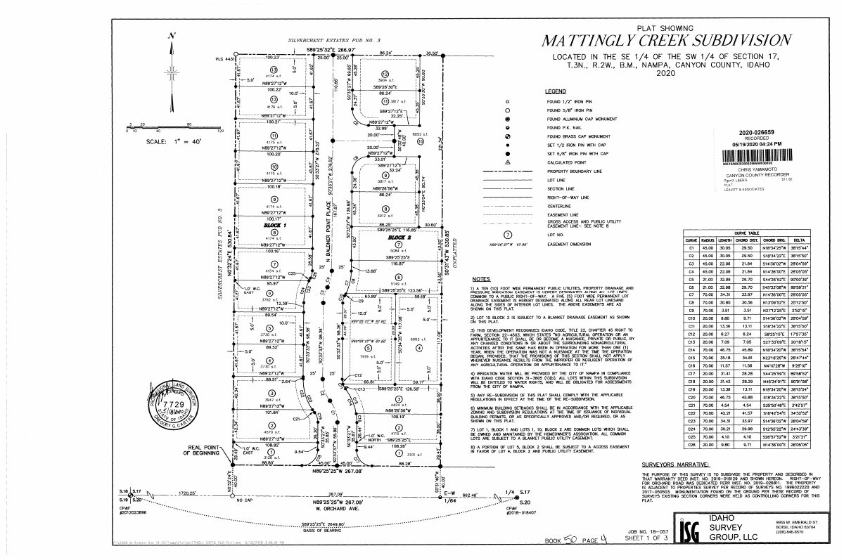
- Download Subdivision plat for Mattingly Creek
Recorded plat map showing lot layout, dimensions, easements, and monuments for the Mattingly Creek subdivision, filed with the county recorder in 2020.
April 24, 2026 · 3 pages · 554 KB · Other/Misc.
Project narrative
- Download Project narrative for property boundary adjustment and lot split
Describes reconfiguring two lots in the Mattingly Creek Subdivision into four lots, consistent with the approved preliminary plat, with zoning and utility service maintained.
April 24, 2026 · 2 pages · 494 KB · Narrative
- Download Record of survey for property line adjustment
Survey map by a licensed surveyor showing parcels C, D, A and B and the boundary adjustment prepared for Red Letter Day, LLC, with a surveyor's narrative and certificate.
April 24, 2026 · 1 page · 423 KB · Record of Survey
Other documents
- Download Parcel C legal description
Metes-and-bounds survey description of a 0.078-acre (3,379 sq ft) parcel carved from portions of two lots in a City of Nampa subdivision, prepared by a surveying firm.
April 24, 2026 · 1 page · 668 KB · Other/Misc.
- Download Parcel D legal description
Metes-and-bounds legal description of a 0.093-acre (4,068 sq ft) parcel carved from portions of two lots in a Nampa-area subdivision, prepared by a land surveying firm.
April 24, 2026 · 1 page · 824 KB · Other/Misc.
- Download Parcel A legal description
Metes-and-bounds survey description of a 0.094-acre parcel (4,085 sq ft) carved from portions of two lots in a Nampa subdivision, prepared by Accurate Surveying & Mapping.
April 24, 2026 · 1 page · 780 KB · Other/Misc.
- Download Parcel B legal description
Metes-and-bounds legal description of Parcel B, a 0.078-acre (3,380 sq ft) portion of Lots 4 and 5, Block 2, Mattingly Creek Subdivision, prepared by a surveying firm.
April 24, 2026 · 1 page · 692 KB · Other/Misc.
- Signed affidavit of legal interest
April 24, 2026 · Affidavit of Legal Interest
- Deed
April 24, 2026 · Proof of Proprietary Interest
- Master application form
Master application form for a property boundary adjustment, filed as part of the planning application.
April 24, 2026 · Checklist & Master Application
- Vicinity map
April 24, 2026 · Vicinity Map