Record of survey · Planning application
Property line shifted to fix driveway encroachment, approved
The City of Boise approved a boundary change between two neighboring lots so a shared driveway sits entirely on one owner's parcel. The approval covers only the lot line change, with no new homes or buildings.
From the filing
The application's description as it appears in City of Boise's record. See the official record
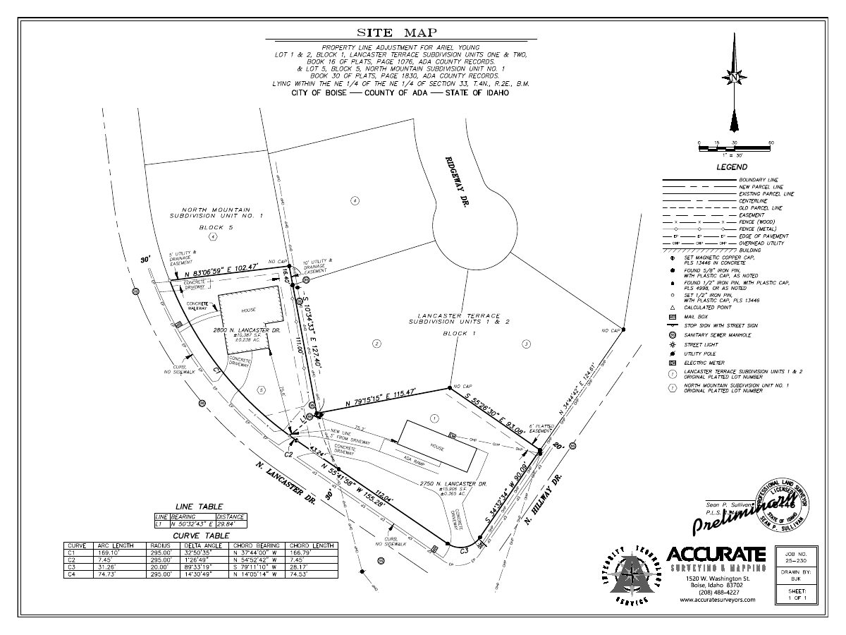
The City of Boise approved a property line adjustment between two neighboring lots at 2750 and 2800 North Lancaster Drive, moving the boundary between them. The change is recorded through a survey map that must be signed, notarized, and filed with the Ada County Recorder before it is final. The approval covers only the lot boundary change, with no new homes or buildings.
Property line adjustment, hillside overlay.
Project name on file: 2750 N LANCASTER DR
Timeline
Jan. 27, 2026
Site Inspection: Not Required
Jan. 27, 2026
Review Complete: Completed
Jan. 27, 2026
Current Planning: Complete
Jan. 8, 2026
Building Plan Reviewer: Complete
Jan. 8, 2026
Building Plan Reviewer: In Review
Jan. 8, 2026
Current Planning: In Review
Jan. 8, 2026
Assign Reviewers: Completed
Dec. 24, 2025
Review Complete: Corrections Required
Dec. 24, 2025
Current Planning: Corrections Required
Dec. 12, 2025
Building Plan Reviewer: Complete
Dec. 11, 2025
Building Plan Reviewer: In Review
Dec. 11, 2025
Current Planning: In Review
Dec. 11, 2025
Assign Reviewers: Completed
Dec. 9, 2025
Fee Payment: Payment Received
Dec. 9, 2025
Prescreen Review: Passed
Dec. 8, 2025
Prescreen Review: In Progress
Dec. 2, 2025
Prescreen Review: Corrections Required
Dec. 2, 2025
Prescreen Review: In Progress
Nov. 19, 2025
Prescreen Review: Corrections Required
Nov. 16, 2025
Prescreen Review: In Progress
Nov. 16, 2025
Application Submittal: ePlanReview
Nov. 16, 2025
Application filed
Documents
Site plans
- Download Updated site map for property line adjustment
Survey sheet showing the proposed property line adjustment between several platted lots, with legend, line and curve tables, and parcel areas.
Jan. 22, 2026 · 1 page · 240 KB · PDS-Maps and Drawings
- Download Site plan
Dec. 12, 2025 · 1 page · 357 KB · PDS-Maps and Drawings
Plans
- Download PDS-Maps and Drawings - LANCASTER TERRACE AMENDED 12-12-25
Dec. 12, 2025 · 2 pages · 464 KB · PDS-Maps and Drawings
- Download North Mountain Subdivision unit plat (record of survey)
Recorded plat sheet for a unit of North Mountain Subdivision, showing lot and block layout, curve data, legend, and restrictive covenant reference, prepared by Tudor Engineering Company.
Dec. 12, 2025 · 2 pages · 529 KB · PDS-Maps and Drawings
Project narrative
- Download Letter of explanation for boundary line adjustment
Applicant's narrative supporting a boundary line adjustment to move a shared boundary so an existing driveway lies entirely on the applicant's parcel, with no new lots created.
Dec. 12, 2025 · 2 pages · 33 KB · PDS-Letter of Intent
Decisions
- Download Administrative approval letter with conditions of approval
Boise City approves a property line adjustment between two lots, subject to conditions requiring revisions to the Record of Survey and submittal of legal descriptions.
Jan. 27, 2026 · 4 pages · 200 KB · PDS-Action Letter
Notices
- Download Notice of administrative approval
City of Boise notice that staff approved a property line adjustment between two parcels, with an appeal deadline of Feb. 2, 2026.
Jan. 23, 2026 · 2 pages · 832 KB · PDS-Legal Notice
Application
- Download Record of survey application for property line adjustment
Application form for a record of survey property line adjustment on a 0.34-acre residential hillside parcel, keeping two lots, with water and sewer connections present.
Nov. 16, 2025 · 2 pages · 204 KB · PDS-Application
Photos
- Download Photographs submitted with record of survey
A six-page set of photographs filed with the record of survey application; the extracted text is garbled image noise with no readable content.
Dec. 12, 2025 · 6 pages · 7.6 MB · PDS-Photos
Other documents
- Noticing radius map
Jan. 23, 2026 · 535 KB · PDS-Maps and Drawings
- Transmittal to agencies
Dec. 17, 2025 · 98 KB · PDS-Transmittal Agencies
- Legal descriptions
Dec. 12, 2025 · 2.2 MB · PDS-Other Small Docs
- Quit claim deed
Quit claim deed filed with the planning application; no text was available to describe its parties or terms.
Dec. 12, 2025 · 92 KB · PDS-Other Small Docs
- Quit claim deed
Dec. 12, 2025 · 58 KB · PDS-Other Small Docs
- Download Record of survey for a property line adjustment
Survey sheet 1 of 1 showing a property line adjustment between two adjoining lots, with new and old lot lines, boundary monuments and recorded references.
Dec. 12, 2025 · 2 pages · 508 KB · PDS-Record of Survey
- Statement of legal interest
Dec. 12, 2025 · 1.4 MB · PDS-Statement of Legal Interest
- Statement of legal interest
Dec. 12, 2025 · 1.6 MB · PDS-Statement of Legal Interest
- Payment receipt
Dec. 9, 2025 · 134 KB · PDS-Receipts


