Property boundary adjustment · Planning application
Nampa approves lot split separating single-family home from apartment complex
The city approved the split on Aug. 22 with conditions, including removal of a rear deck on the single-family home before recording; the county will not issue new parcel numbers until deeds are recorded.
From the filing
The application's description as it appears in City of Nampa's record. See the official record
The City of Nampa approved a property boundary adjustment, also called a lot split, for the property at 347 W Orchard Ave. The approval covers only what is shown on the submitted record of survey. The document gives no details on the number of units or the size of any buildings.
Lot split to separate the single-family residence from the multi-family residence.
Project name on file: Lot Split
Timeline
Aug. 22, 2025
Decision: Approved
June 5, 2025
9 documents added
June 5, 2025
Planning PBA Application Review
June 3, 2025
Completeness Check
May 30, 2025
Application filed
Documents
Site plans
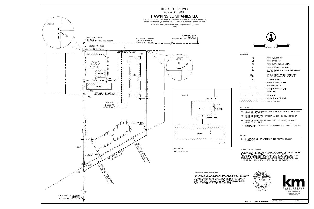
- Download Record of survey for lot split, Parcels A and B
Survey sheet dividing a portion of Lot 4 into Parcel A (0.190 acres) and Parcel B (1.552 acres), prepared for Hawkins Companies LLC by a licensed surveyor.
May 30, 2025 · 1 page · 390 KB · Record of Survey
Project narrative
- Download Cover letter requesting conditional approval for deck removal
Engineering firm's letter asking the city for conditional lot split approval, with proof of deck removal to follow before recording, after a May 16 meeting with city staff.
May 30, 2025 · 3 pages · 426 KB · Narrative
Decisions
- Download Property boundary adjustment approval letter
Letter from the city approving the boundary adjustment, with no comments from engineering or planning and a building department condition to remove back steps or deck before recording deeds.
June 5, 2025 · 1 page · 226 KB · Available Online
Other documents
- Download Legal description of Parcel A
Metes-and-bounds legal description for a 0.190-acre (8,284 sq ft) parcel, with a closure and boundary traverse data sheet, prepared for the boundary adjustment.
May 30, 2025 · 2 pages · 426 KB · Other/Misc.
- Download Legal description of Parcel B
Metes-and-bounds legal description for a 1.552-acre parcel in Lot 4 of Westview Subdivision, with a boundary survey sketch and closure data.
May 30, 2025 · 2 pages · 502 KB · Other/Misc.
- Affidavit of legal interest (signed)
May 30, 2025 · Affidavit of Legal Interest
- Warranty deed from Pura Vida 1 Corp
Recorded warranty deed transferring the property from Pura Vida 1 Corp to a new LLC owner, submitted as proof of proprietary interest.
May 30, 2025 · Proof of Proprietary Interest
- Lot split checklist
May 30, 2025 · Checklist & Master Application
- Vicinity map
May 30, 2025 · Vicinity Map
