Property boundary adjustment · Planning application
Lot line change approved for two single-family homes on church land
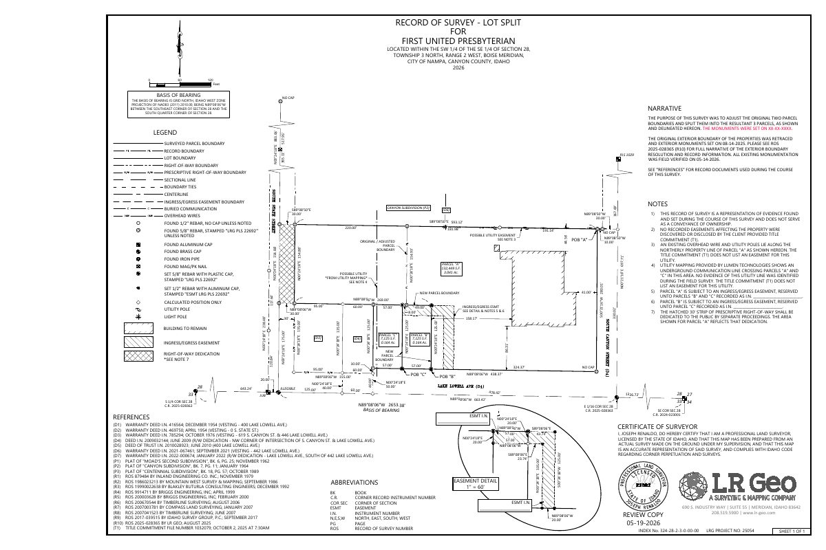
The adjustment turns two lots into four parcels, with two to be gifted to LEAP Housing for homes sold to households earning about 80% of area median income. The homes would be about 1,446 square feet and held in a community land trust.
From the filing
The application's description as it appears in City of Nampa's record. See the official record
A property boundary adjustment was approved for the parcel at 400 Lake Lowell Ave in Nampa, which is zoned RS6. The approval covers only what is shown on the attached record of survey, and no new buildings or units are described.
Make two lots into 4 separate parcels (4 total allowed when using both existing lots), constructing 2 single family homes (detached) 2- 57 x 159 lots = 9,063 sf each
Timeline
June 17, 2026
20 documents added
June 17, 2026
Issue Property Boundary Adjustment Document
June 17, 2026
Planning PBA Application Review
April 10, 2026
Assess Fees (Home)
April 7, 2026
Completeness Check
April 6, 2026
Application filed
Documents
Site plans
- Download Record of survey for lot split
Survey by a licensed surveyor showing the boundary adjustment of two parcels into three, with a basis of bearing, notes on monuments, and easement and utility observations.
May 20, 2026 · 1 page · 780 KB · ROS Lot Split
- Download Record of survey for lot split
Survey by a licensed surveyor showing the adjustment of two original parcels into three resultant parcels, with monuments, bearings, notes and easement references.
April 6, 2026 · 1 page · 796 KB · Record of Survey
- Download Easement sketch between parcels A, B and C
Survey sketch of an easement area within Section 28, with boundary bearings and distances, legend, and a note that a record of survey will be filed.
April 6, 2026 · 1 page · 598 KB · Other/Misc.
- Download Easement sketch for parcels A, B and C
Survey sketch of a 1-inch-to-30-foot easement area across parcels A, B and C, noting that a record of survey will be filed with additional boundary details.
April 6, 2026 · 1 page · 606 KB · Other/Misc.
- Download Easement sketch from parcel B to parcel C
Survey sketch of a 20-foot-wide easement area between parcels B and C, prepared by a licensed surveyor, with bearings, dimensions and a note that a record of survey will be filed.
April 6, 2026 · 1 page · 611 KB · Other/Misc.
Project narrative
- Download Record of survey for property boundary adjustment
Recorded survey retracing the exterior boundary of parcels in the SW 1/4 of the SE 1/4 of Section 28, with basis of bearing, legend, and boundary narrative.
April 6, 2026 · 1 page · 2.5 MB · Other/Misc.
- Download Narrative describing lot split and housing plans
LEAP Housing's letter explains splitting a vacant church-owned lot into two parcels for two single-family homes sold to households near 80% of area median income.
April 6, 2026 · 1 page · 222 KB · Narrative
Decisions
- Download Property boundary adjustment approval letter
Decision letter approving the boundary adjustment after Nampa engineering, planning and building departments reported no comments; notes the county assessor will assign new parcel numbers only after deeds are recorded.
June 17, 2026 · 1 page · 255 KB · Decision Letter
Other documents
- Download Parcel A legal description
Metes-and-bounds legal description of Parcel A, about 3.041 acres, signed by a licensed surveyor on May 19, 2026.
May 20, 2026 · 1 page · 324 KB · Parcel A Description
- Download Right-of-way dedication description and sketch
Surveyor's metes-and-bounds description and sketch of a 0.106-acre (4,646 sq ft) strip dedicated as right-of-way along South State Street, signed May 19, 2026.
May 20, 2026 · 2 pages · 845 KB · ROW Dedication Description
- Checklist and master application
April 6, 2026 · Checklist & Master Application
- Affidavit of legal interest
April 6, 2026 · Affidavit of Legal Interest
- Download Easement description from Parcel A to Parcels B and C
Legal metes-and-bounds description of a 0.068-acre access easement running from Parcel A to Parcels B and C, prepared by a licensed surveyor.
April 6, 2026 · 1 page · 227 KB · Other/Misc.
- Download Easement description from Parcel A to Parcels B & C
Legal metes-and-bounds description of a 0.125-acre (5,466 sq ft) easement, prepared by a licensed surveyor and dated Jan. 8, 2026.
April 6, 2026 · 1 page · 227 KB · Other/Misc.
- Download Easement description from Parcel B to Parcel C
Legal metes-and-bounds description of a 1,140 square foot (0.026 acre) access easement across part of a parcel, prepared by a licensed surveyor.
April 6, 2026 · 1 page · 225 KB · Other/Misc.
- Download Gift agreement with LEAP Charities for church land donation
Signed agreement under which First United Presbyterian Church of Nampa donates a portion of its land to LEAP Charities for affordable homeownership housing, with income restriction, reversion, fence and liability terms.
April 6, 2026 · 3 pages · 781 KB · Proof of Proprietary Interest
- Download Parcel A legal description
Metes-and-bounds legal description of Parcel A, about 3.147 acres (137,095 sq ft), prepared by a licensed surveyor and dated Dec. 15, 2025.
April 6, 2026 · 1 page · 228 KB · Other/Misc.
- Download Parcel B legal description
Metes-and-bounds legal description of a 0.164-acre (7,125 sq ft) parcel, Parcel B, prepared for the property boundary adjustment and signed Dec. 15, 2025.
April 6, 2026 · 1 page · 224 KB · Other/Misc.
- Download Parcel C legal description
Metes-and-bounds legal description of a 0.164-acre (7,125 sq ft) parcel within a property boundary adjustment, prepared by a licensed surveyor and dated Dec. 15, 2025.
April 6, 2026 · 1 page · 224 KB · Other/Misc.
- Vicinity map
April 6, 2026 · Vicinity Map

