Property boundary adjustment · Planning application
Boundary shift between two residential parcels approved
The city approved a request to move the shared property line between two parcels, one with a home on a city lot. The decision was made July 15, about four weeks after the June 18 filing. No new construction is described.
From the filing
The application's description as it appears in City of Nampa's record. See the official record
Parcel line adjustment
Project name on file: Adjusting common line between the two parcels
Timeline
July 15, 2026
Issue Property Boundary Adjustment Document
July 15, 2026
Decision: Approved
July 15, 2026
Planning PBA Application Review
July 6, 2026
10 documents added
June 24, 2026
Assess Fees (Home)
June 24, 2026
Completeness Check
June 18, 2026
Application filed
Documents
Site plans
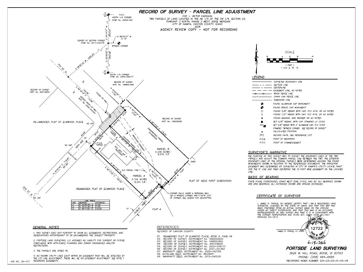
- Download Preliminary record of survey for parcel line adjustment
Agency review copy of a record of survey adjusting the common line between Parcel A and Parcel B, prepared by Portside Land Surveying for the property boundary adjustment application.
June 18, 2026 · 1 page · 270 KB · Record of Survey
Project narrative
- Download Pre-application meeting notes from Nampa Planning & Zoning
City of Nampa planning staff notes from a pre-application property inquiry, listing applicable code sections for landscaping, parking, signs and open space; the text is largely illegible and it is not an approval.
June 18, 2026 · 1 page · 2.9 MB · Other/Misc.
- Download Cover letter for parcel line adjustment
Surveyor's cover letter from Portside Land Surveying requesting a parcel line adjustment to meet the side yard setback, referring to the submitted Record of Survey.
June 18, 2026 · 1 page · 36 KB · Narrative
Correspondence
- Download Applicant response to city staff comments on boundary adjustment
Surveyor Jim Prince responds to the June 25, 2026 engineering and building comments, defending the surveyed boundaries and noting the demolished outbuilding on Parcel B.
July 6, 2026 · 2 pages · 166 KB · Revision Comments from applicant
- Download Engineering review comments on right-of-way dedication
Engineering reviewer asks that the right-of-way dedication line be revised to match existing lot boundaries, which it is offset from by about 9.5 feet along proposed Parcel B.
June 24, 2026 · 1 page · 2.0 MB · ENG Review Comments
Other documents
- Deed
June 18, 2026 · Proof of Proprietary Interest
- Master application form
The master application form for a property boundary adjustment, filed with the planning application.
June 18, 2026 · Checklist & Master Application
- Download Right-of-way parcel exhibit and legal description
Exhibit A survey legal description of a 900 square foot right-of-way parcel, prepared by Portside Land Surveying on June 18, 2026.
June 18, 2026 · 2 pages · 206 KB · Other/Misc.
- Signed affidavit of legal interest
June 18, 2026 · Affidavit of Legal Interest
- Vicinity map
June 18, 2026 · Vicinity Map

