Record of survey · Planning application
Lot line adjustment between two Boise lots approved with conditions
The city approved a property line adjustment moving the shared boundary between two existing lots, with no new homes or buildings described. The approval takes effect only after the appeal period ends Jan. 5 without an appeal, and the revised survey must be signed and recorded.
From the filing
The application's description as it appears in City of Boise's record. See the official record
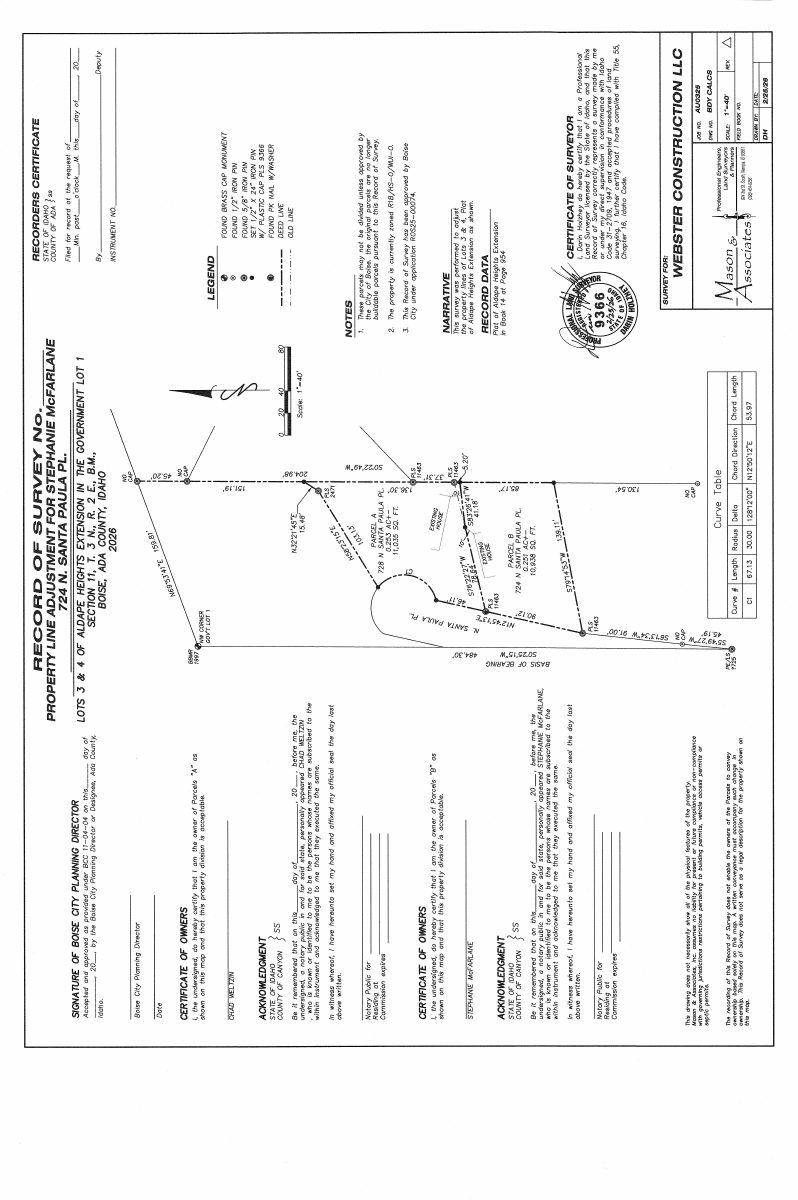
A property line adjustment between Lots 3 and 4 of the Aldape Heights Extension Subdivision at 724 N Santa Paula Place in Boise. The change moves the shared boundary between the two existing lots, and no new buildings or housing units are described.
ROS - Property Line Adjustment
Project name on file: 724 N SANTA PAULA PL - ROS
Timeline
June 6, 2026
Appeal Period: Completed
June 5, 2026
Finalize Record of Survey: Recorded
June 5, 2026
Site Inspection: Not Required
Jan. 5, 2026
Review Complete: Completed
Dec. 26, 2025
Review Complete: Completed
Dec. 26, 2025
Current Planning: Complete
Dec. 23, 2025
Building Plan Reviewer: Complete
Dec. 16, 2025
Building Plan Reviewer: In Review
Dec. 16, 2025
Current Planning: In Review
Dec. 16, 2025
Assign Reviewers: Completed
Dec. 11, 2025
Review Complete: Corrections Required
Dec. 11, 2025
Current Planning: Corrections Required
Nov. 25, 2025
Building Plan Reviewer: Complete
Nov. 25, 2025
Building Plan Reviewer: In Review
Nov. 25, 2025
Current Planning: In Review
Nov. 25, 2025
Assign Reviewers: Completed
Nov. 19, 2025
Fee Payment: Payment Received
Nov. 19, 2025
Prescreen Review: Passed
Nov. 19, 2025
Prescreen Review: In Progress
Nov. 14, 2025
Prescreen Review: Corrections Required
Nov. 12, 2025
Prescreen Review: In Progress
Nov. 10, 2025
Prescreen Review: Corrections Required
Nov. 7, 2025
Prescreen Review: In Progress
Oct. 29, 2025
Application Submittal: ePlanReview
Updated missing fields in Project Details with input from Christy Webster in order to generate the ePlan case.
Oct. 16, 2025
Application filed
Documents
Site plans
- Download Revised record of survey
Revised record of survey sheet for the application, with boundary and lot information; the text is mostly garbled or rotated, so details are unclear.
March 30, 2026 · 1 page · 502 KB · PDS-Record of Survey
- Download Record of survey for property boundary adjustment
Survey map showing a boundary adjustment of two lots into Parcels A and B, with owner certificates, planning director signature block, and notary acknowledgments.
Dec. 2, 2025 · 1 page · 470 KB · PDS-Record of Survey
Plans
- Download Retaining wall drawings
Structural notes and retaining wall design drawings for the McFarlane retaining wall, including design loads, wind and seismic criteria, material properties and rebar specifications.
Dec. 2, 2025 · 4 pages · 8.5 MB · PDS-Maps and Drawings
Project narrative
- Download Revised letter of intent
Property owners notify the city they are taking over permitting for a lot line adjustment and retaining wall project from the prior contractor and list new contacts.
March 30, 2026 · 1 page · 33 KB · PDS-Letter of Intent
- Download Letter of intent for lot line adjustment
Letter from Webster Construction explaining that a record of survey will realign the property line so a failing retaining wall sits on the correct property before replacement.
Dec. 2, 2025 · 1 page · 24 KB · PDS-Letter of Intent
Decisions
- Download Action letter with conditions of approval for property line adjustment
Staff approves a property line adjustment between two lots, subject to revisions to the Record of Survey and submittal and agency requirements before final approval.
Dec. 26, 2025 · 3 pages · 174 KB · PDS-Action Letter
Notices
- Download Notice of approval for record of survey
City of Boise notice that staff found the record of survey for a property line adjustment between two lots consistent with the zoning ordinance and approved it; appeals are due by Jan. 5, 2026.
Dec. 22, 2025 · 2 pages · 779 KB · PDS-Legal Notice
Application
- Download Public Works hillside project questionnaire
A Public Works questionnaire with yes/no answers on parcel changes, grading, driveways and retaining walls for a hillside project, dated 11/19/2025.
Dec. 2, 2025 · 1 page · 676 KB · PDS-Other Small Docs
- Download Record of survey application for property line adjustment
Application for a record of survey documenting a property line adjustment, with two lots before and after, sewer and water connections present, and a Hillside and WUI designation.
Nov. 19, 2025 · 2 pages · 203 KB · PDS-Application
Studies and reports
- Download Retaining wall structural calculations
Engineering calculations for the McFarlane retaining wall, covering design criteria (2018 IBC, seismic, wind, snow), soil pressures and a cantilevered retaining wall analysis.
Dec. 2, 2025 · 30 pages · 5.3 MB · PDS-Other Small Docs
- Download Geotechnical engineering report
Geotechnical evaluation with two hand-auger subsurface borings to 10 feet, plus earthwork, bearing capacity, retaining wall and drainage recommendations for the properties.
Dec. 2, 2025 · 21 pages · 1.2 MB · PDS-Other Small Docs
Photos
- Download Site photos
Six photographs of the site, dated Nov. 19, 2025, filed with the record of survey application.
Dec. 2, 2025 · 6 pages · 41.3 MB · PDS-Photos
Correspondence
- Download Fire Department comments
Boise Fire Department approves the parcel line adjustment as presented, with wildland-urban interface, defensible space and hydrant/access conditions for future changes.
Dec. 26, 2025 · 2 pages · 233 KB · PDS-Agency Comments
- Download Parks and Recreation Department comments
Boise Parks and Recreation reviewed the application with Community Forestry and has no comments or recommendations.
Dec. 26, 2025 · 1 page · 57 KB · PDS-Agency Comments
- Download Addressing plan review comments
Addressing technician's review confirming both parcels keep their existing addresses, and asking to be notified once the survey is finalized.
Dec. 26, 2025 · 1 page · 66 KB · PDS-Agency Comments
- Download Building plan review comments
Plan review found no comments on the final record of survey, but notes that a retaining wall will need a separate building permit.
Dec. 26, 2025 · 1 page · 106 KB · PDS-Agency Comments
- Download Public Works sewer comments
Public Works reviewed the record of survey and returned no objections or comments on the sewer and irrigation review.
Dec. 26, 2025 · 1 page · 10 KB · PDS-Agency Comments
- Download Building plan review comments
Plan review found no comments on the final record of survey, but notes that a retaining wall will need a separate building permit.
Dec. 2, 2025 · 1 page · 106 KB · PDS-Agency Comments
Other documents
- Download Ada County Assessor new parcel numbers form
Assessor's land records parcel activity form assigning new parcel numbers after a quitclaim deed transfer, listing affected parcels in the Aldape Heights Extension land group.
June 5, 2026 · 2 pages · 748 KB · PDS-Other Small Docs
- Download Notice of buildable parcel for property line adjustment
Recorded notice creating a new buildable parcel (Parcel B) by property line adjustment, with legal descriptions of the original and new parcels; valid only once the city planning director's certificate is signed.
June 5, 2026 · 8 pages · 1.7 MB · PDS-Other Small Docs
- Download Record of survey for a property line adjustment
Recorded survey plat adjusting the property lines of two lots in Aldape Heights Extension, with owner certificates, notes on zoning, and surveyor certification.
June 5, 2026 · 1 page · 674 KB · PDS-Record of Survey
- Download Notice of buildable parcel for property line adjustment
Draft notice describing the legal descriptions of the original and new buildable parcels for a property line adjustment, with a planning director certificate still unsigned.
March 30, 2026 · 4 pages · 328 KB · PDS-Other Small Docs
- Download Notice of buildable parcel for property line adjustment, revised
Revised notice describing Parcel B, a buildable parcel created by a property line adjustment between Lot 3 and Lot 4 of Aldape Heights Extension, with a Boise City signature certificate required.
March 30, 2026 · 4 pages · 781 KB · PDS-Other Small Docs
- Statement of legal interest from neighbor
March 30, 2026 · 73 KB · PDS-Statement of Legal Interest
- Noticing radius map
Dec. 22, 2025 · 544 KB · PDS-Maps and Drawings
- Transmittal to agencies
Dec. 3, 2025 · 99 KB · PDS-Transmittal Agencies
- Download Parcel A legal description
Metes-and-bounds legal description of Parcel A, combining all of Lot 4 and part of Lot 3 of a recorded subdivision, prepared by Mason & Associates for Webster Construction, dated August 27, 2025.
Dec. 2, 2025 · 4 pages · 155 KB · PDS-Other Small Docs
- Statement of legal interest
Dec. 2, 2025 · 658 KB · PDS-Statement of Legal Interest
- Payment receipt
Nov. 19, 2025 · 134 KB · PDS-Receipts

