Record of survey · Planning application
Three Boise lots become two in approved parcel consolidation
The city approved combining two existing parcels and adjusting a property line with a neighboring parcel, leaving two new parcels. The filing does not describe any new homes or buildings, and the recorded survey and easement changes are complete.
From the filing
The application's description as it appears in City of Boise's record. See the official record
This recorded document amends an earlier shared access, utility, and landscape easement on land at 1022 W Targee St in Boise. The amendment reflects a parcel line adjustment that turns three existing parcels into two new parcels. The easement's dimensions are not changing.
Parcel Consolidation
Project name on file: 1022 W Targee St
Timeline
Dec. 24, 2025
Appeal Period: Completed
Dec. 23, 2025
Finalize Record of Survey: Recorded
Dec. 23, 2025
Site Inspection: Conditions Met
Nov. 14, 2025
Review Complete: Completed
Nov. 14, 2025
Current Planning: Complete
Oct. 28, 2025
Current Planning: In Review
Oct. 28, 2025
Assign Reviewers: Completed
Oct. 22, 2025
Fee Payment: Payment Received
Oct. 22, 2025
Prescreen Review: Passed
Oct. 22, 2025
Prescreen Review: In Progress
Oct. 15, 2025
Application Submittal: ePlanReview
Oct. 15, 2025
Application filed
Documents
Site plans
- Download Site plan with boundary notes and easement references
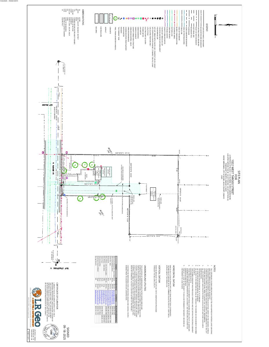
Site plan for a surveyed parcel, showing topography sources, the existing house on parcel A to remain, and shared access and ACHD easements tied to the parcel consolidation and line adjustment.
Oct. 30, 2025 · 1 page · 1.5 MB · PDS-Maps and Drawings
Plans
- Download Record of survey draft, parcel consolidation and property line adjustment
Draft record of survey consolidating two original parcels into two new parcels via a property line adjustment, with basis of bearing, monument notes, and zoning note R-1C.
Oct. 30, 2025 · 1 page · 994 KB · PDS-Maps and Drawings
Project narrative
- Download Record of survey, parcel consolidation and property line adjustment
Recorded survey consolidating original parcels B and C and adjusting the common boundary with parcel A, with monument notes, zoning note, and county recorder certificate.
Dec. 23, 2025 · 1 page · 4.3 MB · PDS-Record of Survey
- Download Letter of intent for parcel consolidation and property line adjustment
Explains the request to consolidate two parcels and adjust a shared boundary, resulting in two buildable parcels in compliance with R1-C zoning.
Oct. 30, 2025 · 1 page · 661 KB · PDS-Letter of Intent
Decisions
- Download Amendment to shared access, utility, and landscape easement
Recorded amendment to a 2025 easement declaration, reflecting a parcel line adjustment that turns three parcels into two; the easement dimensions are unchanged.
Dec. 23, 2025 · 4 pages · 1.2 MB · PDS-Other Small Docs
- Download Parcel consolidation action letter with conditions of approval
Boise City Development Services approves a parcel consolidation and property line adjustment, subject to a list of record of survey revisions and submittal requirements.
Nov. 14, 2025 · 4 pages · 206 KB · PDS-Action Letter
Notices
- Download Notice of buildable parcel for parcel consolidation and property line adjustment
Recorded notice describing the legal descriptions of an original parcel and a new buildable parcel, valid only once a Boise City deputy planning director certificate is signed.
Dec. 23, 2025 · 5 pages · 2.0 MB · PDS-Other Small Docs
- Download Notice of buildable parcel for consolidation and property line adjustment
Recorded notice describing a buildable parcel from a consolidation and property line adjustment, valid only once the Boise City Deputy Planning Director certificate is signed.
Dec. 23, 2025 · 7 pages · 3.0 MB · PDS-Other Small Docs
- Download Notice of approval for parcel consolidation and lot line adjustment
City of Boise notice that staff found the project follows the zoning ordinance and was approved, with an appeal deadline of November 24, 2025.
Nov. 12, 2025 · 2 pages · 684 KB · PDS-Legal Notice
Application
- Download Record of survey application for parcel consolidation
Application to consolidate three existing parcels into two lots on a 0.587-acre residential single-family property in the R-1C zone, with sewer and water connections present.
Oct. 15, 2025 · 2 pages · 204 KB · PDS-Application
Correspondence
- Download Addressing comments on record of survey
Addressing review confirms two parcels keep their current addresses and one address retires upon consolidation, and asks to be notified once the survey is finalized.
Nov. 14, 2025 · 1 page · 154 KB · PDS-Agency Comments
- Download Boise Fire Department comments
Fire Department review approving the parcel consolidation and boundary adjustment subject to access road, addressing signage, and no-parking requirements.
Nov. 14, 2025 · 2 pages · 244 KB · PDS-Agency Comments
- Download Boise Parks and Recreation comments
Parks and Community Forestry ask whether existing mature trees shown on the survey will be retained, and require coordination on public trees and easements before building permits.
Nov. 14, 2025 · 1 page · 59 KB · PDS-Agency Comments
- Download Public Works sewer comments
Public Works civil engineer reports no objections or comments on the sewer and irrigation review for this record of survey.
Nov. 14, 2025 · 1 page · 10 KB · PDS-Agency Comments
- Download Street light comments from Public Works
Public Works street light trades supervisor reports no comments on the Record of Survey application.
Nov. 14, 2025 · 1 page · 125 KB · PDS-Agency Comments
- Download Veolia Water fire flow availability letter
Water utility letter reporting available pressure and flow at a nearby hydrant, for use in fire sprinkler design and plan sets.
Oct. 30, 2025 · 1 page · 73 KB · PDS-Other Small Docs
Other documents
- Download Ada County Assessor parcel activity form
Assessor's land records form tracking parcel splits, ownership and assessor descriptions tied to a recorded record of survey (ROS 15151) and related parcel work orders.
Dec. 23, 2025 · 1 page · 33 KB · PDS-Other Small Docs
- Noticing radius map
Nov. 12, 2025 · 633 KB · PDS-Maps and Drawings
- Payment receipt
Oct. 31, 2025 · 134 KB · PDS-Receipts
- Download Notice of buildable parcel for minor land division
Recorded notice identifying a new buildable parcel created from Block 1 of a subdivision, with legal descriptions of the original and new parcels; not valid until the city's deputy planning director certificate is…
Oct. 30, 2025 · 14 pages · 5.6 MB · PDS-Other Small Docs
- Download Declaration of shared access, utility, and landscape easement
Recorded declaration by the property owner granting shared access, utility, and landscaping easement rights over parcels divided under a City of Boise approval.
Oct. 30, 2025 · 8 pages · 3.0 MB · PDS-Other Small Docs
- Download Parcel A legal description
Metes-and-bounds legal description of Parcel A, about 8,083 square feet (0.186 acres), prepared by a licensed surveyor for the record of survey.
Oct. 30, 2025 · 1 page · 339 KB · PDS-Other Small Docs
- Download Parcel B legal description
Metes-and-bounds legal description of Parcel B, a portion of a warranty deed parcel, with monumented boundary courses and the point of beginning.
Oct. 30, 2025 · 2 pages · 280 KB · PDS-Other Small Docs
- Statement of legal interest
Oct. 30, 2025 · 272 KB · PDS-Statement of Legal Interest
- Submittal checklist
Oct. 30, 2025 · 231 KB · PDS-Submittal Checklist
- Transmittal to agencies
Oct. 30, 2025 · 99 KB · PDS-Transmittal Agencies
- Payment receipt
Oct. 22, 2025 · 135 KB · PDS-Receipts


